The Trent-Severn Waterway: Ontario’s Summer Playground
by Harry W. Pope
|
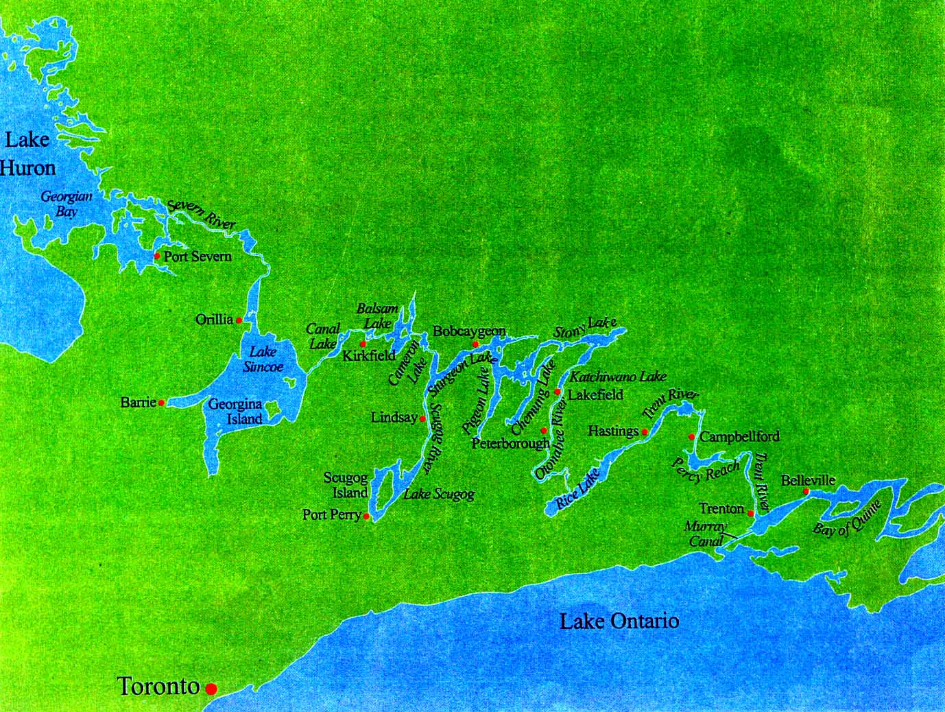
Considered one of the most beautiful, unspoiled stretches of inland waterway in North America, the Trent-Severn meanders across the Canadian province of Ontario for some 240 miles, linking Lake Huron and Lake Ontario.
The waterway begins on the eastern edge of Lake Huron, where a cluster of islands clings to its rocky coastline. Boaters enter from Georgian Bay, traveling up the Severn River, passing through clear waters with tall pines and Precambrian cliffs lining both banks.
The upstream journey along the deeply-gorged Severn leads into shallow Lake Couchiching and its reedy shores lined with willows. The route then moves on into the huge expanse of Lake
Simcoe.
From here, the waterway winds along the Talbot River to Canal Lake, and then into Balsam Lake where two opposite flowing watersheds are linked - the Severn and the Trent. The Severn flows westward, while the Trent flows eastward toward Lake Ontario. Balsam Lake marks the summit of the waterway. With a surface elevation of 840 feet, it is the highest point on earth to which a boat can be piloted from sea level.
Along its way, the Trent will pass through numerous rural towns and smaller cities before flowing through open country, across lush rolling farmland, then dropping sharply in elevation as it winds its way toward the Bay of Quinte at the very edge of Lake Ontario.
In early times, Huron Indian tribes relied on this system of lakes, rivers, and portages for hunting and transportation, as well as for their forays into neighboring Iroquois Indian territory. Striking evidence of their settlements can be found in rock carvings near Burleigh Falls and at Serpent Mounds overlooking Rice Lake.
 |
| A canal cut near Kirkfield. |
The European explorers and traders who came to the New World quickly discovered this corridor of lakes and rivers and used it to venture inland, ship supplies, and move pelts in the active fur trade which soon developed.
In the 1860s, a number of lumber firms were established along the Severn River, and the loggers began to press for creation of a water route. They saw it as a means of shipping the huge white pines from forest to mill in unprecedented quantities. Others with even wider vision saw the waterway project as a means of moving wheat from the Canadian prairies to East Coast cities.
It was in the 1870s that an inland water route was first considered. However, at that time, Canada was sparsely populated and politicians paid little attention to rural concerns. but the dream stayed alive.
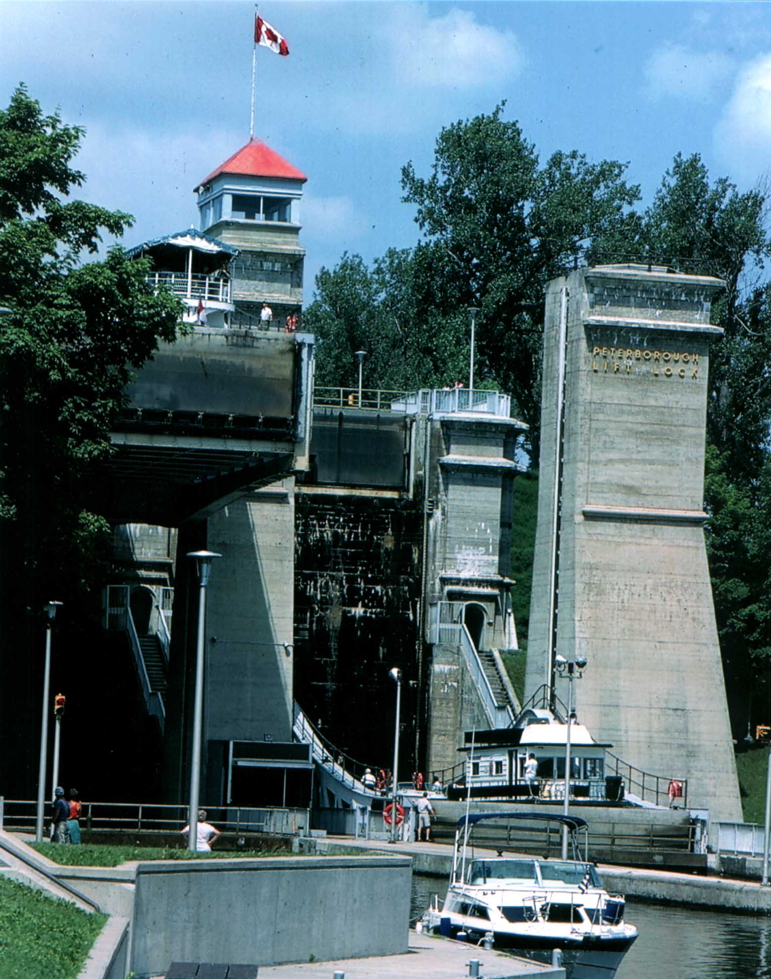 |
| The Peterborough Lock, built in the 1900s, raises or lowers vessels 65 feet. |
Construction proceeded in localized fits and starts until politician Sir John A. MacDonald, in an 1882 election campaign, promised the waterway would be built. The vote-catching ploy worked. His Conservative party was elected, and before long, men, horses, and steam engines were at work on various sites, blasting rock, digging canals, and installing massive limestone blocks into lock walls and dams. The first locks were built at Bobcaygeon in 1883.
Construction work was suspended during World War I, so it was not until 1920 when the waterway was completed. In July of that year, the motor launch Irene became the first vessel to navigate the entire 240-mile length of the new Trent-Severn Waterway.
The winding route of the Trent-Seven flows under 60 bridges, passing through 44 locks, two of which are huge hydraulic lift locks built in the early 1900s. Located at Kirkfield and Peterborough, they were constructed to overcome an extraordinarily steep drop over a relatively short stretch of water.
The Kirkfield lock has chambers 140 feet long, with a width of 33 feet, a normal depth of eight feet, and a lift of 48 feet. The lock at Peterborough has the same general dimensions, but its lift is 65 feet. The combined weight of water and steel in a single lock chamber is 1,700 tons.
But the realization of a dream which had taken 140 years to accomplish was marred by irony: The reasons which had led earlier generations to press for the waterway were no longer valid. The logging industry had gone into a decline, and a burgeoning railway system now carried grain and goods to the major cities, making the once-visionary Trent-Severn Waterway obsolete for commercial shipping.
As the years passed, light traffic along the route necessitated only minimal upkeep, and staffing at the many locks was drastically cut. In fact, at one time, the Canadian Department of Transportation considered closing the waterway down. In Parliament, politicians argued that instead of maintaining the Trent-Severn for nonexistent shipping, sections should be filled in and used as roads or railway rights-of-way.
But times changed. A buoyant post-War economy in the late 1940s and early 1950s saw many people buying boats. The scenic Trent-Severn now had a purpose: a route for recreational boaters and a major tourist attraction.
This unique corridor of lakes and rivers spectacularly carved by nature and linked by man-made canals is a favorite haunt for daytrippers. Picnic facilities are located at every lock, and easy access to the water draws fishermen at all hours of the day and night.
Owners of cruising boats berthed in Chicago, Detroit, Cleveland, and New York annually make their way to the
Trent-Severn, joining the many smaller boats being piloted along its waters.
The Kawatha Voyageur is the only commercial cruise ship traveling the length of the waterway. Owned and operated by Ontario Waterway Cruises Inc., the diesel-powered vessel was constructed in 1983. It has a capacity of 38 passengers in 19 cabins. Five-day cruises sail between Peterborough and Kingston. An alternative is to sail from Peterborough to Big Chute on the Severn River, or from Big Stream upstream to Peterborough. For further details, call 1-800-561-5767.
Other operators offer shorter cruises. Typical is Skylark VIII, based in Lindsay. This 48-passenger boat sails the Scugog River, Sturgeon Lake, and adjoining waters. Sunset cruises and Sunday brunch cruises are also available. Call Lindsay Parks Board at 705-324-8335 for information. Houseboat rentals are popular with families and small groups, offering the opportunity to cruise at will. One such operator is Happy Days Houseboat Rentals Ltd. at Bobcaygeon, 705-738-2201.
Canadian Small-Craft Charts: 2021, 2022, 2023, 2024, 2025, 2028, 2029
Construction of an all-Canadian commercial water route connecting Lake Ontario with Lake Huron’s Georgian Bay through a chain of interior lakes and rivers was begun in 1827. When finally completed, the Trent-Severn Waterway's commercial value was already obsolete. Nevertheless, new locks and canals were built periodically until the entire system limped to completion in 1920, with marine railways instead of locks at two places. One of those railways was replaced with a lock as recently as 1964.
Although never commercially viable, the Trent-Severn has become an invaluable recreational resource. Winding among hills and farms, past quiet villages and a couple of energetic cities, as well as through island-studded lakes and placid rivers, this scenic and sheltered waterway lures thousands of cruising skippers every summer.
The waterway is operated by Parks Canada during daytime hours from mid-May to mid-October. Controlling depth is approximately five feet, and overhead clearance of the fixed bridges is 22 feet. Sailboats can have their masts stepped or unstepped at Belleville or Trenton at the southern end of the canal, and at Midland or Penetanguishene on the northern end.
Most towns and resort areas along the Trent-Severn have commercial marinas, and all locks have reasonably priced tie-up walls for overnight dockage. Many locks also have pleasant picnic areas. All have restrooms, but no showers.
A diligent skipper and crew can transit the Trent-Severn’s entire 240-mile length in six days. Because there is no Lock 33, and no need to pass through Lock 29 unless you take a long sidetrip, the route passes through 43 locks.
Canal Fees. in addition to tolls, vessels must pay a mooring fee to tie up overnight at lock approach walls (plus a few other walls along the canal). See the Lockage and Mooring Fees table for more information.
Charts. All seven of the Canadian small-craft charts listed a the beginning of this chapter are necessary. The charts are available at Randalls Bookstore, 24 Dundas Street, West, in Trenton or by mail order from Friends of the Trent-Severn waterway at 1-800-663-2628. They also can be purchased at Lock 1, in the store operated by Friends of the Trent-Severn Waterway.
Locking. Trent-Severn lock tenders do not monitor VHF radio. Before transiting the lock, tie up to the blue line to wait. Do not blow your horn. After the lock opens, and after all boats have exited, watch for a hand signal from the lock master, or a green light, before entering. If only one gate is opened, the lock tender wants you to tie up on that side of the lock.
In most locks, water enters through small gates located at the bottom of the upstream lock gate. Be alert for the turbulence near that gate.
All such gate-type locks have numerous cables hanging down both sides of the lock, covered with black plastic. Choose two cables (one near your bow and the other near your stern) and loop your bow line around one and your stern line around the other. Cleat one end of each line and tend the other end. Turn engines off; tend both lines at all times; and wait for the lock tender’s signal to cast off.
Draft. If your vessel draws five feet or more, telephone the Trent-Severn Waterway Headquarters in Peterborough at 705-750-4900 to check current depths.
Lock 1. Lock 1 is a busy stop. Unless you already have a season pass, you must purchase your lock pass here.
Locks 2-6. All five of these locks are relatively isolated. All have tie-ups on walls above and below the lock. Upper wall tie-ups are often more spacious and closer to the lock house and to the restrooms. Additionally, until you arrive at Lock 43 (the first descending lock) you can get underway earlier in the morning - before the day’s first locking.
|
Types of Permits Available |
Lock 7, Glen Ross. This lock has attractive grounds and good tie-ups both above and below. Only a few steps from the upper wall is the Variety Store, selling some of the tastiest ice cream cones on the canal.
Mile 21.8, Blue Hole Anchorage. Anchor behind the island in eight to 10 feet. Enter and leave via the upstream end to avoid the shallower water and weeds at the downstream end. This is one of the best anchorages along the canal.
Lock 8, Percy Reach Lock. Tie up above or below the lock. Both spots are attractive and both have picnic tables.
Lock 9, Meyer’s Lock. The tie-up above the lock is best.
Lock 10, Hagues Reach Lock. The preferred tie-up is at the top of the lock, on the east side.
Locks 11 and 12 (Ranney Falls Locks). One of only two such pairs of locks on the system, these are tandem locks. Also referred to as flight locks, both locks share a common gate. A small anchorage with nine-foot depths is located just below the locks in a corner of Ferris Provincial Park.
Mile 31. Cambellford is the largest town since Trenton. Tie up along the west wall in front of the Chamber of Commerce building. Once you step ashore, you are in Old Mill Park - A beautiful downtown city park. A small fee, payable at the chamber building, covers your overnight tie-up with water and electric hookups and the use of restrooms and showers. Three supermarkets and other shopping are nearby.
Lock 13, Cambellford Lock. Tie up on the southwest (port) wall.
Lock 14, Crowe Bay Lock. Lock up on the east wall.
Locks 15, 16, 17. Going up, lock on your port side in all three locks. Locks 16 and 17 are tandem locks.
If you feel a need to get away for the night, or afternoon, proceed north past the entrance of Lock 15 and drop your anchor in the spot of your choice.
|
Types of Mooring Fees |
Mile 41, Slaughter Island Anchorage. Anchor off the waterway in the northeast cove in 10 feet.
Mile 42.3. Anchor east of Marker “T316”.
Mile 45. Anchor east of steam Mills Island.
Lock 51, Hastings. Tie up above or below the lock. A supermarket, liquor and beer stores, hardware store, pharmacy, several restaurants, and a laundromat are within a block and a half of the lock. Farm-fresh vegetables can be purchased within 50 feet of the upper wall tie-up.
Mile 51 to 57. Depending upon the wind direction, several reasonably good anchorages can be found along the shore between Hastings and Rice Lake. One of the best is along the south shore at mile 54.7.
Rice Lake, Miles 57-69. If the west wind is up, the 17-mile passage of this relatively open water lake may appear to be a bit longer. If this is your first crossing, study the chart beforehand to sort out the islands. Because some markers are so far apart, you will be navigating by island positions as often as marker positions. Consider plugging in a few GPS waypoints before you start across, particularly the position of Marker “T429” at mile 67. The line of “submerged cribs” here (five -foot depths) is all that remains of a railroad bridge that operated from 1855 to 1861.
Mile 68.5. A large florescent red triangle buoy marks the turning point into the Otonabee River.
Gores Landing. If it is late in the day, you might consider staying the night at Gores Landing instead of pressing on to Peterborough, still 20 miles and a lock away. Gores Landing is located in a cove along the southwest shore of the lake, a mile and three quarters southwest of the Otonabee entrance buoy. The full-service Coxies Cove Marina is here, with transient space and repair facilities. Next door is a fine restaurant.
Mile 69.6 Anchorage. The only good all-weather anchorage in the vicinity is located a quarter-mile west of Marker “C-5”. Leave the waterway channel very close to the south side of Marker “C-5”. Anchor in the crook of the deep water channel in six to 14 feet. The cove located a mile and a quarter further on toward Peterborough (behind Marker “7”) is crowded with homes and boats and is not a suitable anchorage.
Mile 73.7, Public Wharf. Unless it is already occupied by fishermen, the tiny Campbelltown Wharf can handle one or two smaller vessels overnight. The public wharves between Campbelltown and Peterborough are not recommended for overnight stops.
Mile 89. Peterborough. Home to Locks 19, 20 and 21, Peterborough is the largest town (population 65,000) on the Trent-Severn. The municipal marina is nestled between Locks 19 and 20 in a park on the south shore of Little Lake. This is the last opportunity for a “real city stop” until reaching midland on the shores of Lake Huron.
Much of downtown Peterborough is within walking distance of the marina, and the rest is a short bike ride away. You can find everything you’d expect in a small city, including a Boater’s World marine store. Those that arrive on Wednesday or Saturday are in for a special treat - the spectacular Festival of Lights, an evening lights and water show.
The public dock around the corner from the marina is suitable for daytime use but, because of a constant flow of visitors, is not recommended for overnight.
|
Distances - |
Lock 20. Leaving downtown Peterborough, you pass through Ashburnham Lock before arriving at famous Peterborough Lift Lock.
Mile 90, Peterborough Lift Lock. Although overnight tie-ups are not allowed, stop long enough at the west wall, just below the lock, to tour the Visitors’ Center and learn precisely how a hydraulic ram lock works.
Mile 93.7, Trent University. The canal passes right through the campus of this beautiful, ultra-modern Canadian university. Have your camera ready.
Mile 99, Lakefield. Five and a half miles and five locks past Trent University is the town of Lakefield. A favorite stop among cruisers, Lakefield has three tie-up wall locations that provide easy access to town. The first (farthest from town) is along the upper wall of Lock 26. The second is along the east wall of the canal just above the bridge, and the third is just above the bridge on the west side of the canal, in front of the Trent-Severn Canal Maintenance Compound. A fourth overnight choice is the Lakefield Marina, a half-mile north of the bridge. Although it is much smaller than Peterborough, Llakefield has a broad range of services and shopping.
Mile 103 Anchorage. Anchor behind Douglas Island in 10 feet.
Mile 104.5, Lock 27, Young’s Point. Virtually on the lock grounds is the Lockside Trading Company, a fascinating shopping experience. One of the older locks, it is a popular but charming area with space to tie up both above and below the lock.
Mile 113, Lock 28, Burleigh Falls. Due to strong currents at the lower walls, tie up only at the upper walls. There used to be a flight lock here. Ever since the two locks were replaced by a single lock, the canal has been without a lock 29.
Mile 114.8, Lock 30, Lovesick. Remote and very attractive, Lovesick Lock is understandably popular and most often full, with no tie-up space left for the latecomer.
Anchorage, Mile 116.4. When there is little wind or when the wind is out of the north, a good anchorage can be found northeast of marker “C261”, in the deeper water between the arm of Dinnertime Island and the adjacent little unnamed island.
Anchorage, Mile 120.1. When there is no space along the Lock 31 walls, the long, narrow, north shore cove below the lock (between markers “C280” and “C284”) makes a good alternative overnight stop.
Lock 31, mile 120.6. Buckhorn is the halfway point on the 240-mile Trent-Severn. Because of its popularity, the long walls on the top the lock are often filled to capacity. That popularity is due to its handy location at the doorstep of a bustling town with a complete array of stores and services. Buckhorn Yacht Harbour, a full-service marina with water, electricity, and marine store, is about a mile beyond the lock.
Note: To continue along the main route of the Trent-Severn Waterway, turn from Chart 2023, Sheet 2 of 3, to Chart 2024, Sheet 1 of 5.
Anchorages, Mile 122. The east shore beyond Buckhorn has several bays that can serve as an overnight anchorage.
Mile 129.5, Oak Orchard. During the mid 1980s, the point of land just east of here was home to “Three Buoys,” a 144-houseboat charter operation. Years before, it was a corporate retreat for OMC executives.
Lock 32, Mile 138, Bobcaygeon. Traveling north on Pigeon Lake, you won’t see Lock 32 entrance buoy “C345” until long after you think you should see it. First to come in view will be the large, faded, orange triangle on Beacon Island.
Dating back over 165 years, Lock 32 is the oldest lock on the Trent-Severn system. Big Bob Channel leading to the lock is one of the most picturesque portions of the trip. Just before the lock is a swing bridge with an 11.5-foot closed clearance. Tie up at blue line if you wish to make passage through. Bobcaygeon is a wonderful town to stroll. Everything is at hand, even a supermarket. Gordon Yacht Harbor is the transient, full service marina here.
Note: Skippers following the Trent-Severn direct route should now go directly to Sheet 1 of Chart 2025, skipping over Sheets 3, 4, and 5 of Chart 2024.
|
Tentative Hours of Operation |
Sturgeon Lake, Miles 139-153. With the first two-thirds open to southwest winds and the remaining third open to the north winds, this 14-mile lake is usually a speedy passage - except in foul winds.
Mile 153.5, Lock 34, Fenelon Falls. With the exception of the Chute and the Severn Falls lock, Fenelon Falls is one of the most crowded locks on the canal. No matter when you lock through, you will have a large audience appraising your locking style from the top of the east wall. Fenelon Falls’ popularity stems from a combination of factors: convenience to the highway, a fine selection of restaurants and downtown stores virtually at lockside, plus the fact that it is the last major supply stop for boaters until Orillia, 50 miles away.
Mile 157, Lock 35, Rosedale. Unlike Fenelon, there will be no audience here to watch you lock. Often however, because of its attractive grounds, there may be little or no tie-up space left.
Mile 163.5 Tie-Up. Except in an east wind, the canal breakwater wall at the west side of Balsam Lake is a good, free, overnight tie-up. Regardless of the wind direction, use heavy fendering to protect against the occasional large wakes of passing boats.
Mile 169.5, Lock 36. Kirkfield is the second highest hydraulic lift lock in North America (Peterborough was the highest). It is also the first down lock since Trenton. Because it is all “downstream” from here to Lake Huron, the buoys are reversed for the remainder of the canal.
The town of Kirkfield is almost two miles to the south. However, just a few minutes walk from the lock, on the highway to the north, is the lively Lock’s Nest restaurant.
Miles 177-181, Locks 37 (Bolsover), 38 (Talbot), 39 (Portage), 40 (Thorah), and 41 (Gamebridge). These five attractive locks in less than four miles lead to Lake Simcoe. With the occasional exception of Gamebridge, there is usually ample overnight tie-up space.
If the weather forecast for Lake Simcoe is ominous, consider waiting it out at one of these locks. A second alternative is to lay over on the wall just inside the Lake Simcoe breakwater. In heavy weather, a surge can enter from the lake and make this area uncomfortable. A final option is to stay over at Hendry’s Trent Talbot, a full-service marina located halfway between Lock 41 and the lake. Watch for its sign.
Miles 182-197, Lake Simcoe Crossing. Use Chart 2028, Sheet 1 or 2, to cross the lake. At first glance, it may seem like a relatively small lake. But the scale of this chart (half-inch to a mile) is approximately six times smaller than the other Trent-Severn charts. The buoys are two to three miles apart. Even with ideal conditions, you won’t be able to see from one to another. In addition, many landmarks are too far away to recognize.
None of the above are of any great concern on a clear, windless, and waveless day. Unfortunately, there are few such days on Lake Simcoe. We therefore recommend:
1. Try to cross in the morning when the wind is normally lighter and the thunderstorms are fewer.
2. If you have GPS aboard, determine the positions of the buoys that mark the route and plug in the waypoints before you start out.
3. Don’t cross when the forecast is marginal.
Mile 197.5, The Narrows. The frenzy of boats encountered in the vicinity of The Narrows, particularly on a weekend, is unmatched by any other location on the canal. Four facilities here have transient docks: Blue Beacon, Mariners Pier, Orchard Point, and Hammock Harbor. Only Hot Knots Landing had diesel in 1998.
Mile 198.8, Port of Orillia. Tucked in behind a huge breakwater and on the grounds of a city park, The Port of Orillia Marina was designed with transients in mind. To reach this marina, leave the main canal route at Nadie Island (a mile beyond The Narrows) and follow the marked channel west for approximately two miles. About the only thing the marina doesn’t have is fuel. Less than a five-minute stroll away is the Front Street Shopping Center with a supermarket and drugstore. Restaurants abound throughout the area. Even a marine supply store is within a few blocks. A bit farther inland is Orillia’s downtown (population 24,000). Daytime dockage is free and overnight rates are reasonable.
Just five miles away on the other side of Lake Couchiching is Casino Rama, a 24-hour casino with more than 2000 slots, 100 gaming tables, three restaurants, and a free casino shuttle that stops hourly at the marina.
Leaving the marina to return to the main Trent-Severn channel via Chief Island, you will see two of the most popular anchorages of the whole waterway - popular in spite of the fact that landing on the island is prohibited.
Mile 210, Lock 42, Couchiching. The first lock since before Lake Simcoe, Couchiching is a popular overnight tie-up. A small snack bar adjacent to the lock serves breakfast. Only 2.5 miles beyond the lock is a swing bridge with an eight-foot closed clearance that doesn’t swing before 8:30 a.m.
Deep Bay Anchorages, Mile 216.5. Depending on the wind direction, several coves along the bay’s shoreline can provide some good anchorages, particularly the southeastern corner.
Mile 218-224. Depending on the wind direction, a number of anchorages can be found along this six-mile stretch.
Mile 224.5, Lock 43, Swift Rapids. This “isolated” lock has the highest lift of any conventional lock on the system - 47 feet. Both the upper and lower walls are popular overnight tie-ups.
Mile 228, Severn Falls. Transient dockage is available here at the long, floating government dock that is overlooked by JB’s Landing Restaurant.
Lost Channel Anchorages, Mile 230.5. Several peaceful anchorages can be found by those willing to explore this off-channel arm.
Mile 232.5, Big Chute Marine Railway Lock. You Won’t learn how long your wait will be until you arrive at the railway and count the boats tied up to the long floating dock with the blue line. If there is room to tie up at that dock, it should be a relatively short wait. If there is no room, you’ll be here for awhile. Arrive early on a weekday morning to give yourself an edge.
The lock masters communicate by loudspeaker. Instead, the lock tenders communicate by loudspeaker. Listen carefully for their instruction. If this is your first time, observe the boats locking through ahead of you.
When directed to enter, take your fenders in, go slowly, and in the event yours is not a standard underwater hull, be prepared to point out to the lock masters where the after sling should, or should not, be placed.
Overnight transient space is available above the Chute at Big Chute Marina.
Mile 233.5, Little Chute. This narrow channel often has a substantial current. A sign at the channel entrance directs you to give a horn signal to alert any upbound vessels that you are
downbound.
Mile 240.5, Lock 45, Port Severn. Lock 45, the last lock on the canal, also appears to be the smallest, and one with delays that may match those of the big Chute.
Below the lock is Lake Huron’s Georgian Bay, where navigation markers will again reverse. Upon leaving the lock, they will be red to starboard and green to port.
Charts of the waters beyond Port Severn are found in the “Georgian Bay Small Craft Charts Series.” These charts are similar to those of the Trent-Severn. Chart 2202, Sheet 1 of 5, covers the 10-mile route from Lock 45 to Midland.
Midland. Although there are other Georgian Bay ports where the next phase of the Great Loop Trip can begin, Midland is a good choice for several reasons:
• It is the largest city in the vicinity.
• Most supplies are readily available.
• Boat and engine repairs are readily available.
• Sailboat masts can be stepped at Bay Port Marina.
• The municipal marina, Midland Harbour Town Dock, is located just a few steps from downtown.
Called the “Murals of Midland,” twenty-five Murals are sprinkled about the city on the sides of buildings. Pick up a map showing their locations from the marina or the Chamber of Commerce.
Harry Pope is a freelance writer who lives in Ontario, Canada.