Southern
Exposure
by Craig Brady & Ruth Reed
 The rolling hills and old oaks of the Kentucky
countryside fell behind us as we crossed the Kentucky Lake Dam. With the view of the lake
unfolding before us, we caught a wink of the September sun sparkling on the water below.
In the distance, a tiny speck of a sailboat worked its way over the horizon. Our
confidence was shaken as we looked in astonishment at the vastness of the lake. The
honeymoon adventure was just beginning. Kentucky Lake would test our limited sailing
experience on our first bareboat charter.
The rolling hills and old oaks of the Kentucky
countryside fell behind us as we crossed the Kentucky Lake Dam. With the view of the lake
unfolding before us, we caught a wink of the September sun sparkling on the water below.
In the distance, a tiny speck of a sailboat worked its way over the horizon. Our
confidence was shaken as we looked in astonishment at the vastness of the lake. The
honeymoon adventure was just beginning. Kentucky Lake would test our limited sailing
experience on our first bareboat charter.
Webster defines experience as "knowledge from doing." We had
very little knowledge of sailing until January of 1997 when we attended Strictly Sail in
Chicago. The show was a perfect distraction from the cold and snow of winter. We walked
aimlessly through the large exhibition of sailboats at Navy Pier imagining ourselves
sailing each and every one of them. The boats sat motionless in a sea of people. They were
ordinary people, like ourselves, touring the boats and dreaming of sailing. We left Navy
Pier that day promising ourselves we too would sail some day.
Only two months later, our commitment to sailing became a reality with
the purchase of our first sailboat. Using the literature from Strictly Sail, we discovered
an old sixteen foot Lindsey Newport at Hooper's Yachts in Afton, Minnesota. On a cold
March day, we drove into the icy boat yard of Hooper's Yachts. Huddled in the small cuddly
cabin of the Newport, we watched our breath turn to vapor while debating over its
purchase. Since then, our small boat has been a forgiving teacher and peaceful retreat.
Our summer weekends were spent in the Newport on Lake Storey, a small
lake in Galesburg, Illinois. Built as a water source for the railroads, this narrow
mile-long lake lends itself better to the local fishermen than fledgling sailors. The lake
was our classroom while the Newport taught us lessons in tacking, jibing, sail trimming
and a cardinal lesson in gear storage. The discipline of securing gear on a sailboat was
brought to a head one windy day when the port-a-potty, left perched on a bunk, was sent
rolling through the cabin. It has not been unsecured since then.
Labor Day weekend brought an end to our sailing season. The days were
getting shorter, our weekends were occupied with wedding arrangements and Lake Storey's
water level was dropped below the boat ramps. Regrettably, we covered the Newport for
winter storage yearning for one last trip. While making honeymoon plans, we began
wondering if our experience would allow us to charter a cruise. After surfing the net and
making a few phone calls, we were pleasantly surprised to find we could reserve a new
Hunter 23.5 from Lighthouse Landing on Kentucky Lake.
The ease of our week-long honeymoon on the Hunter still astounds us.
Our initial concerns about our ability to handle a larger boat subsided when we began our
checkout and instruction on the Hunter. Typically a checkout would only consist of
verifying a sailor's competence in seamanship but with our limited experience, we chose to
include an additional two hours of instruction. In that short period of time, Steve, our
instructor reviewed the basics of sail trimming, heaving to, reefing, man overboard
procedures and anchoring. Late that afternoon, we sailed out of the marina on our own with
new confidence in our abilities.
Our first destination was an easy sail across the lake to Cow Bay. The
name comes from a herd of bovine that drink from its shores early in the morning and wake
the slumbering yachtsman with their cow bells. We sailed into the bay as the sun dipped
below the horizon spewing warm colors into the evening sky. While securing the boat for
the night, we watched the survival tactics of the host of tiny fish. Hundreds of aquatic
performers burst from the surface of the water giving the illusion of a shower of
raindrops. As they continued their show late into the night, we drifted asleep discovering
the hypnotic effects of wavelets lightly slapping the hull and gentle motion of lying
quietly at anchor.
The next morning low stratus clouds drifted overhead and a cool light
rain created steam on the water as we turned south on a beam reach out of Cow Bay.
Uncertain of our destination, we traveled down the lake knowing our next anchorage would
be determined by the wind and weather. The clouds soon became darker and more ominous and
the increasing wind filled our sails. We were inexperienced in these weather conditions
and naively continued at a fast pace. Our unwitting situation became obvious when one of
our new "ultimate hats" went overboard. "Man overboard," rang out from
the cockpit. We thought we had this maneuver under control but we quickly realized it was
testing the limits of our abilities. After two hurried attempts to recover the unsinkable
victim, we lost sight of the hat in the white caps and abandoned the rescue. The situation
continued to deteriorate until we finally took control by having to shorten sails. The
experience taught us the importance of being prepared to react to any situation.
Steve demonstrated anchoring techniques during our instruction at
checkout. The gusty winds blowing out of Pisgah Bay on the second night tested our skills.
We motored the Hunter as far back into the cove as the water depth allowed and let the
danforth dig into the Kentucky clay. During the night, every creak of the anchor rode or
lurch of the boat acted as a wake-up call for us to check our position. Wearied out, we
drank our coffee the next morning with the anchor still holding firmly to the bottom of he
cove.
The morning weather report predicted another rainy, cold day. There
were seven more major bays lining the eastern shore of Kentucky Lake for exploration. We
passed each one by however, on our way to Kenlake Marina where a restaurant and hot
showers were waiting.
Southern hospitality is alive and well along Kentucky Lake, especially
at the marinas. Greeting us with a kind smile, the young man at Kenlake Marina offered us
not only the customary services but graciously provided us with transportation to the
showerhouse at a nearby campground,. After sailing through the chilling wind and rain for
two days, the hot showers at the park renewed our spirits.
Refreshed and eager to settle in for the night, our Hunter carried us
across the lake from the marina to a small cove. Darkness was approaching as we discovered
the water level in the bay was lower than the charts had indicated, forcing us to turn
away. Our only option was to return to the marina for the night. In an agonizingly slow
operation, we navigated our way in the darkness to the buoys marking the entrance to
Kenlake. Once the Hunter was safely docked under the marina lights, we shuddered at the
foolishness of sailing in the dark.
The skies were clear the next day and the wind freshened from the
north. While the sun warmed its deck, we turned the Hunter into the wind for our journey
home. By midday, we were dropping the hook in Duncan Bay. With our wet clothes hung from
every lifeline and hamburgers grilling off the stern, we discovered the contentment of
relaxing at anchor in the afternoon sun.
A pair of Mallard hens ducked into he bay and migrated to our stern. At
first we were surprised by this begging duo until we understood their duck etiquack.
Obliging the wise quackers, we threw out some crackers which filled their bills. As the
crackers ran out, they ruffled their feathers and we wondered how fowl these two might
become. Just then, a young family on a large yacht motored past. The captain's greeting
carried a strong French accent and the Tricolor flew from its stern. The ducks, preferring
French cuisine, flocked to this floating bistro as it anchored close by.
Since it was our last night on the water, we chose solitude by slipping
the anchor and sailing to a small cove nestled in the back of the bay. Curling up under a
blanket in the cockpit, we watched as the stars appeared one by one in the evening sky. A
satellite arched across the heavens and briefly turned brilliantly white as the sun
reflected off its surface. A falling star burst into flames overhead tracing a line
between two stars before dying again into the blackness. There was not a sound of
humanity. A fish splashed in the water and coyotes howled into the moonless sky. The
vastness of the lake that seemed so overwhelming just days before now paled in comparison
to the world around us.
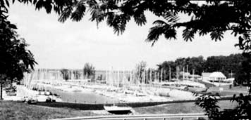 |
Kentucky Lake's
miles of shoreline offer secluded hideaways as well as convenient resources for the
cruising sailor. |
Early Friday afternoon, after an easy sail north, we motored back
through the breakwater at Lighthouse Landing. To some, this would seem hardly a story
worth telling. Kentucky Lake is small in comparison to the Great Lakes. For us, Kentucky
Lake was a body of water that took us over the horizon. Some would say a Hunter 23.5 is
hardly a cruising sailboat. But the Hunter was eight feet longer than anything we had ever
sailed before and seemed like a yacht to us. To a blue water sailor, the forty miles we
traveled would hardly qualify for the term cruising. However, that distance would have
been a marathon in our Newport tacking back and forth across Lake Storey. It all depends
on your perspective. To a pair of new sailors, we conquered the impossible while being
quite ordinary.
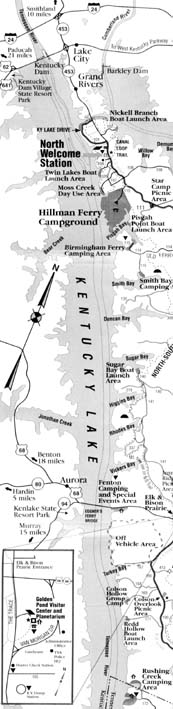
Kentucky Lake bounds the western side of the 270 square miles Land
Between the Lakes National Recreational Area. It was created by an impoundment of the
Tennessee River and is located east of Paducah, Kentucky. The lake is unencumbered for 184
miles with a highly irregular shoreline of over 2,000 miles. Somewhere on those shores,
there is an "ultimate hat" for the finder.
Charter Cruising Destinations
Kentucky Dam Village Marina and Restaurant
This state park marina has a dock for patrons using the restaurant.
They have a full menu and a daily buffet with buffalo featured a couple times each year.
You will find the finger pier to the far right after you pass through the break wall. The
marina is close to the dam on the west side of the lake. The offset break wall entrance
can be identified by a large blue anchor just to the left of the cut. Overnight dockage is
not allowed at the restaurant pier.
Sledd Creek (Turpins Pond)
There are no services in this bay located directly across the lake from
Lighthouse Landing. Some private residences occupy the north side of the bay, but the
south side is undeveloped. The short 2 mile trip across the lake makes this a great first
or last night anchorage. The large area to the left after you enter the bay has good
protection from prevailing southwest winds and good depth and bottom for easy anchoring.
Cow Bay
Again on the west side of the lake and about 2 1/2 miles due south of
Lighthouse Landing, this bay is another favorite for the beginning or end of a charter. It
is directly across the lake from a prominent microwave tower which is located about 3/4 of
a mile south of the canal to Barkley Lake. The best over night anchorage is toward the
back and to the right hand side of the bay. Like most of the areas on Kentucky Lake, the
bottom is clay and your primary danforth anchor set off the bow is all that is needed for
a secure nights stay. You will probably be awakened by the cows drinking at waters edge in
the early morning (hence the name). When entering and leaving use the north side of the
mouth of the bay. There is a serious shoal in front of this bay. If you cross anywhere
near the middle of south of the entrance you will run aground and, if all else fails, you
can arrange for a tow by calling us on VHF channel 16 during normal business hours.
Lunch Stops
O'Brien Branch and Nickell Cove are the first two bays south of the
canal on the Land Between the Lakes side. Each Bay is a good place to drop the lunch hook,
but not a great place to spend the night.
Moss Creek
This is the first bay in the Land Between the Lakes to offer good
protection for overnight anchorage. This bay is directly in the Hillman Ferry Campground,
so there is a lot of activity here. There is also a sand beach, small dock and bath house
close by. All facilities are for the use of registered campers. Your best bet for an
anchorage is in the finger to the left and not in front of the beach where a lot of
fishing boats come through going to and from the launch ramp. Milfoil (seaweed) sometimes
grows in this area and can be a nuisance by clogging your engine cooling intake or filter.
Pisgah Bay
While Pisgah Bay is about 1 1/2 miles long and has good protection and
holding ground, it might be passed up for some of the other large bays further south. The
drawback is the presence of two campgrounds, Hillman Ferry and Pisgah Point, and two boat
launching ramps. Both of these factors generate a lot of power boat traffic, especially on
weekends and holidays. Either the northwest or southeast ends will have good water depth
and bottom for anchorage. The wind direction will dictate which end you choose in heavy
weather. The quieter, more secluded spot is the southeast end.
Smith Bay
At mile 32 on the Land Between the Lakes side, Smith is a large bay
offering some good anchorages and relative seclusion. Enter at the south or middle of the
bay to avoid a small shoal on the north shore of the entrance.During lower water periods,
there is a natural sand beach on the south shore just around the point from the day
marker. Near the beach, and the finger on further back are both good anchorages. A finger
by the day mark on the north shore is also a small lake access camping area. There are
normally only a handful of campers using this campground.The North-South hiking trail can
be accessed along the shore of the back 1/3 of this bay.
Duncan Bay
Over half a dozen great spots to drop the hook for the night. You could
spend your entire charter overnighting in this bay and stay at a different place each
night. Take the north side of the entrance wide to avoid the shoal there. Once in the bay,
the choice is yours. There are no campgrounds or lake accesses in Duncan Bay. If someone
is already in a good spot, just move to another. Like Smith, Duncan is a winter wildlife
sanctuary. It is not unusual to see deer and other animals watering there. Great blue
heron are plentiful in the area and can stir your imagination with their prehistoric
squawk.
Sugar Bay
Entering this bay on the south side will put you over a shoal area that
is a problem in lower water. The only other area of concern is also only a problem when
the water is a couple feet below summer pool.There is a 350 foot contour that pushes the
channel close to the south side of the bay. Once the first finger to the north is off your
port beam you are well clear. There are 7 excellent anchorages in this bay, including an
open area all the way bay in the main bay. A lake access area with associated light
camping and boat launch is located in the second finger about a mile into the bay on the
south side. From Sugar Bay, the closest facilities will be at Kenlake Marina about 8 miles
to the south.
Higgins Bay
The entrance to Higgins shoals on the more normal down stream or north
side of the bay. It's only a problems in low water and is easy to avoid. Ewes Branch is
the major finger in Higgins and allows for good protection in most weather. Some milfoil
growth occurs in the shallower back parts of this area and should be avoided. An
interesting feature in Higgins is the island (at normal pool) at the mouth of Ewes Branch.
Exploring this small island will reveal one of many old cemeteries in the Land Between the
Lakes area. Another good anchorage is just behind or to the east of the island. During
lower water the area between the island and mainland dries out. It is not passable at
normal pool.
Jonathan Creek
A very large bay on the west side of the lake that is home to several
fishing marinas.The channel is narrow and services are not compatible to sailboats.
Kenlake Marina is easier to get into and better suited for the cruising sailor.
Rhodes Bay
Pretty much a straight in bay with little protections from the open
lake and the prevailing south west winds. A good lunch stop by Higgins would be a better
choice for spending the night in this part of the lake.
Savells
Some protections in this small bay is afforded along the south side all
the way back, but it is still pretty open to the lake. Be sure to stay close to the south
side when entering.
Vickers Bay
If you enter on the south side there is good depth almost all the way
back into this moderately sized bay. Near the front of the bay there is a good spot to
anchor near what could be considered a primitive beach area. You may find house boats
pushed up to the beach, especially on weekends.
Barnett Bay
The last bay before the Eggner Ferry Bridge is a smaller version of
Vickers. It is easy to identify because of the pipeline clearing to the north and the
bridge to the south.At this point you are 17 miles from Lighthouse Landing and radio
contact is marginal, even from the middle of the lake.
Eggner Ferry Bridge
The main channel spans is 57 feet above the water during normal pool
(water level elevation 359 feet above sea level). The channel is well marked and clearly
leads to the main span which is the only span to use going under the bridge. Of course,
you should stand by while commercial traffic passes under. Once under the bridge, the
secondary channel splits off to the right to take you into Ledbetter Creek and Kenlake
Marina.
Kenlake Marina
Call ahead on VHF channel 16 to arrange dockage at this State Resort
Park.This marina has a small dockside restaurant, ice, water and other supplies. A pumpout
is available at the marina to empty the holding tack.The resort restaurant is quite like
the one at Kentucky Dam State Park. You can get directions to walk to it (mostly up hill)
or the park will send a van to give you a lift. Arrangements can be made through the
marina staff.The return trip works the same way but the down hill hike may be a welcome
opportunity to stretch your legs. Another possibility worth considering is the Brass
Lantern restaurant in Aurora, Kentucky.Aphone call will normally bring a limo to carry you
to and from this popular steak house any day except Monday and Tuesday.
Ledbetter Creek
If you did not choose a transient slip at the marina, departure after
dinner will have you looking for a place to drop the hook. Ledbetter is a good choice.
Even though it is on the commercial side of the lake, it is surrrounded by the park so
there are no houses or businesses. Good depth and protection is available in both fingers
of the bay. If you head south when you leave the bay you should be careful to stay in the
marked channel. There is a secondary channel on the shallow west side of the lake and a
cross channel to get you back to the east side of the lake. Leave the green and red
intersection buoy on you starboard side and then take the green buoys on your starboard
side to cross the lake.
Ginger Bay
A narrow entrance to this Land Between the Lakesbay, at mile 53 on the main channel,
opens into a large well protected and scenic anchorage. Nearly anywhere around the
perimeter of the bay can be used for an overnight stop. There is one shallow spot off the
south side just east of the basin at the front of the bay. A lake access area means the
usual light camping and boat ramp.
About Sailing Breezes Magazine
Please send us your comments!!
All contents
are copyright (c) 1998
by Northern Breezes, Inc. All information contained within is deemed reliable but carries
no guarantees. Reproduction of any part or whole of this publication in any form by
mechanical or electronic means, including information retrieval is prohibited except by
consent of the publisher.