 Leica has unveiled a new package that combines the power and accuracy of a 12
channel DGPS/beacon receiver and a high-quality multi-function graphics chart plotter.
Leica has unveiled a new package that combines the power and accuracy of a 12
channel DGPS/beacon receiver and a high-quality multi-function graphics chart plotter. Leica has unveiled a new package that combines the power and accuracy of a 12
channel DGPS/beacon receiver and a high-quality multi-function graphics chart plotter.
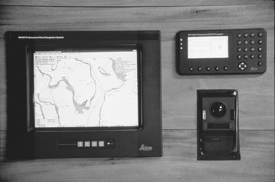
The new MX 480 Professional Charting System includes a Leica MX 412B professional DGPS navigator integrated with a high-resolution chart plotter that can show either raster or vector charts in full color. The subsystems are tightly integrated so that position, routing and alarm data are automatically exchanged between the two. The mariner can immediately view the vessel’s position on a highly detailed chart and can easily enter waypoints and routes with point-and-click commands. The route information is automatically stored in the MX 412B’s memory banks.
The MX 412B is a top-of-the-line 12 parallel channel GPS navigator with a built in DGPS beacon receiver and combined antenna, providing the industry’s benchmark for accuracy and performance at sea. The product has won accolades throughout the marine electronics industry for it’s bright, high resolution display and broad range of navigation functions not found in their GPS receivers.
In the MX 480 system, the MX 412B functions as a stand-alone fully functional DGPS receiver. All of its critical navigation functions and NMEA interfaces continue to operate, even if there is a failure in the main computer or if it is being used for other purposes.
"The unique combination of the MX 412B and the separate chart plotter display provides the best of both worlds for the serious navigator," said Mangs. "The user can have all of the highly acclaimed MX 412B screens, plus the convenience of a color chart display for real-time positioning and waypoint/route entry.
Leica GPS is a business unit of Leica Geosystems. Based in Torrance, California, Lieca GPS designs, manufactures and market professional products using the Global Positioning System (GPS) for a broad range of survey, mapping, navigation, positioning, machine control and other applications.
Leica Geosystems, with worldwide headquarters in Heerbrugg, Switzerland, has more than a 100-year heritage as one of the leading instrument and system innovators in surveying, photogrammetry, industrial measurement and navigation. Leica is a worldwide registered trademark that stands for quality and service.
All contents are copyright (c) 1998 by Northern Breezes, Inc. All information contained within is deemed reliable but carries no guarantees. Reproduction of any part or whole of this publication in any form by mechanical or electronic means, including information retrieval is prohibited except by consent of the publisher.