 |
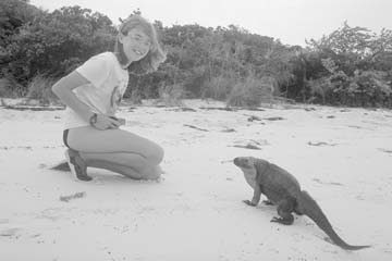
Kate meets one of the friendly iguanas on Allen's Cay in the Exuma Cays, Bahamas |
|
Kate meets one of the friendly iguanas on Allen's Cay in the Exuma Cays, Bahamas |
Out of Bounds sailed into the Bahamas at North Cat Cay after a fairly good crossing of the Gulf Stream. We had left Biscayne Bay, Florida about 3AM and got out of Government Cut in Miami about 4AM. Our daughters, Kate and Kenna, and I were all wearing our wonderful anti-quease wrist bands. Tom, luckily, doesn’t seem to be affected by sea sickness. The wind was a brisk 15-20 knots out of the SE and the waves weren’t too bad, since they weren’t going against the strong current in the Gulf Stream. They started at about six feet but subsided to about 4-5 feet later in the day. Kenna was sick and then felt well. Kate did really good. I felt a bit uncomfortable but not too bad. The cats only drooled. They aren’t the greatest sailors yet and spent most of their time hidden under our rigid dinghy which we keep stored on the foredeck.
We put a small rip in our foresail where it must have been rubbing against the spreader, but otherwise our crossing was uneventful, perhaps because we had carefully chosen the weather for our crossing. It’s important to watch the weather and wait for the proper window to cross the Gulf Stream. The stream flows north at about 2.5 knots and northerly winds pushing against this strong current can produce huge waves that no pleasure boat should be out fighting. In the winter months, northerlies pass quite regularly and after the front passes, the winds generally clock around, from north to northeast to east and so on. Sailors need to wait a day or so after the northerly, for the waves to calm down and the wind to click over to the southeast. This will provide a smoother crossing. Sailors who wait until the winds come over to the southwest may find the seas too high to safely navigate the cuts into the Bahamas.
We sailed into the cut between North Cat Cay and Gun Cay and were anchored by about 5PM. It was too late to go through customs, so with yellow quarantine flag flying, we waited until the next morning. The next day we spent about an hour filling in forms and then paid $10 for a cruising permit and $20 for a fishing license (it covers the entire boat). Kenna lowered the quarantine flag and Kate raised the Bahamian courtesy flag. I was officially a Bahama Mama.
That night we had our first (of what would prove to be many) cold fronts come through. The winds were about 35 knots out of the west (Florida) with loads of rain and endless thunder and lightning. It was a little creepy because the only thing between us and all that ocean, all the way back to Miami, was this little tiny island with no trees. The island was so low that I could see the huge waves crashing on the other side.
We survived. The next day it was still too windy to cross the Bahamas Banks so we got out our old foresail and our ancient Singer sewing machine and did a little sewing on some worn seams. Then we raised our old foresail on the rollerfurling in place of the newly torn sail that would need some more extensive repairs.
The following morning, we raised anchor and headed across the banks towards the Berry Islands. We had to wait for daylight so we could visually navigate a reef. We wished we could have left earlier because we had many miles to go. The sail across the banks was wonderful. "Out of Bounds" danced across the crystal clear turquoise water in depths of eight to ten feet. We didn’t make it to the Berries before dark so we had to anchor right on the banks. We soon had lots of neighbors; about six other boats that couldn’t make it all the way across the banks in daylight.
In the Bahamas, you must sail in good light, as there are few navigational aids to guide you. You soon learn to read the water depths by the color of the water. It is so amazingly, breathtakingly clear. White means very shallow; sand. Black means coral; go around. Then there are a dozen colors of blues and greens. When you can clearly see the bottom; and watch a starfish inch its way around; it’s hard to believe you are in 20 feet of water. Tom took to this "eyeball navigation" easily. I was a bit skeptical but even I learned fairly quickly. Usually we are sailing in about 10-20 feet of water and the color is just like the blue-green of a swimming pool!
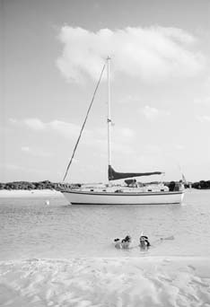 |
Kate and Kenna snorkeling in front of Out of Bounds in the Exuma Land and Sea Park |
After a calm and peaceful night spent anchored on the banks, we raised sails and headed into the nearby Tongue of the Ocean, which lay between us and Nassau. Here the water was a deep purplish-black. By late afternoon we reached the island of New Providence and received permission to enter Nassau Harbor (a formality done over the VHF with Nassau Harbor Control) and anchored in the busy, narrow harbor. The first night in Nassau, we dinghyed into a dock in search of a telephone. Telephones can be hard to find and even harder to make a connection on. But this dock appeared to belong to a restaurant or resort and we thought we would have a good chance of making a call to the states to let family know we had arrived safely. It was low tide and we had found a very high dock. Tom managed to climb onto the dock while the rest of us stayed in the dinghy. We didn’t know that the dock belonged to a Club Med. Perhaps we could have partied for free all night. But Tom did manage to make his calls with the help of some very friendly Club Med personnel.
We had heard that Nassau was ugly, smelly and full of crime but we found the city to be quite nice. They drive on the wrong side of the road here - they probably think it’s the right side - but you do have to be careful to look the RIGHT way before you cross. Kate and Kenna loved bargaining at the Straw Market. We tried conch fritters and found them absolutely delicious! We walked around town and saw a few tourist sites. Tom and the girls visited several old forts, which they NEVER miss no matter where we go. We bought a few provisions at a City Market (which is the same grocery chain we used to shop at in Colorado). Of course everything cost about 2-3 times the price in the states. Thank goodness we had provisioned well before we left the states (in fact we had staples and canned goods to last us for four months) so we only had to buy some fresh produce.
After several days in Nassau, we sailed across the White and Yellow Banks to the Exuma Cays. The Exumas are a chain of islands running 90 miles, from Beacon Cay in the northwest at the Great and Little Exuma Cays in the southeast. The cays are bordered on the west by the shallow Exuma Banks and on the east by deep Exuma Sound. There are approximately 365 cays in the Exumas, most of which are uninhabited.
Our first stop was Allen’s Cay. The only inhabitants here are iguanas. Very friendly iguanas. We snorkeled for the first time over a coral reef - which was like visiting another world. We saw coral in all sizes, shapes and colors and fish in all sizes, shapes and colors. It is so unbelievably beautiful. We saw blue angelfish, french angelfish, parrotfish, stoplight fish, clown fish, triggerfish, squirrel fish, groupers, sergeant majors, grunts, jacks, snappers, and so many more that we have yet to identify. We also saw Barracudas. We would spend hours snorkeling and it seemed like minutes! In fact we spent so much time snorkeling over the next few months that Kenna, who loves to sing while she floats along at the surface gazing at everything beneath her, wore out the mouthpiece of her snorkel!
We were happy to slow down and spend some time in one spot, so we stayed at Allen’s Cay for about a week. While here, we prepared for the next cold front that was forecast to come through. We dove on our anchors to make sure they were well set. There is a strong current that goes through the anchorage at Allen’s Cay so we had to set two anchors. We are very happy with our newest anchor, a Max and we use a Danforth as our second anchor. We also have a CQR as our third anchor. Quite a few of the boats in the anchorage had trouble when the front hit. Many dragged anchors and a few that hadn’t checked out their swing room, went aground at low tide in the middle of the night. I was glad that we’d had plenty of experience anchoring. The Bahamas can be a hard place to learn - especially this past winter with the constant fronts coming through. And there appeared to be a lot of people who were new to cruising.
Next we sailed further south down to Norman’s Cay but because there was a really BIG front coming in a few days and the anchorage at Norman’s wasn’t as secure as we liked, we only spent one night there. Much of Norman’s used to be owned by a Colombian drug lord, now in prison, so many of the buildings on the cay are abandoned. There’s a half submerged airplane in the anchorage. Norman’s Cay does have a cistern where you can fill your water jugs or do your laundry (by hand).
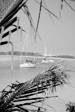 |
Warderwick Wells in the Exuma Land and Sea Park. |
Exuma Land and Sea Park was our next destination. We sailed down beautiful Exuma Sound and arrived at Warderick Wells, the park headquarters, by noon. The park does not allow anchoring at Warderick Wells but instead has mooring balls for rent in a very secure anchorage. The anchorage is beautiful. We followed the deep blue channel which curves along the shore in a horseshoe shape to our reserved buoy. The center of the anchorage - just outside the deep channel - is all shallow sand which is exposed at low tide. So about twenty feet off of our boat was sand on one side and twenty feet off the other end was the island. We were immediately greeted by Bannaquits, tiny yellow breasted birds, which perched on our lifelines, our pedestal and even flew down below. They sang and flitted around, completely oblivious to the cats who stared at them in disbelief.
The park boundaries are about 30 or 40 miles long and no fishing is allowed. Everything, including shells are protected. The warden, Ray Darville, and his family live at Warderick Wells. They generate their own electricity and all of their water is collected from rainfall. Like us, they homeschool. The entire park is run by volunteers (except for the warden who gets a salary) and by donations. While we were there Tom built the park an "electric chair." It’s a comfortable sitting bench which covers and protects all of their battery banks. The girls also did some volunteer work. They organized and cleaned the three shelves of the book exchange and sanded a decorative ship’s wheel. For all of our volunteer work, we were given six of our ten nights on the mooring buoy for free.
Our first night there the park hosted a potluck "Happy Hour" which was lots of fun. It gave us a chance to meet the park personnel and our cruising "neighbors."
While at the park, we had our strongest and biggest front of the winter come through. We got our weather forecasts over the HAM or SSB Radio as neither NOAA nor local weather reports were broadcast in this uninhabited area. We listened to Herb Hilgenberg on Southbound II on 12.359 MHz upper sideband, who gives detailed forecasts to cruisers all over the Atlantic Ocean, the Caribbean and the Bahamas. He begins his report at 4 PM Eastern Daylight Time. Herb was forecasting west winds possibly up to hurricane force. I wasn’t happy about that. The warden did tell us that the mooring buoys had withstood 90 knots of wind, although the manufacturer rates them at 35 knots. And although it is illegal to put down anchors because it upsets the ecosystem that the park is trying to protect, Ray gave everyone (20 boats on the moorings) permission to put down an extra anchor. Ray and park volunteers also handed out chafing gear and helped to make sure that every boat was secure.
With everyone, including park headquarters, battened down, the storm arrived. It wasn’t quite as bad as I had imagined although we did get sustained winds howling at 50 knots. Fortunately we had chosen an excellent anchorage and we were very protected. There were a few guys who I heard over the VHF all night long that weren’t too happy about the shrieking winds (they kept yelling, none too calmly, that this was the worst wind they had ever been in) and one boat got struck by lightning and lost a lot of electronics. Tom had already unplugged all of our electronics except the VHF. Of course, the worst winds always seem to come at night and things always seem better in daylight. The wind blew very hard for about four days, making it impossible to leave because the cuts were impassable. But, after four days of winds blowing at 40-50 knots, fronts packing 25 and 30 knot winds, seem like a breeze.
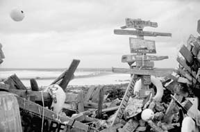 |
At the top of Boo Boo Hill, at Warderick Wells, we discovered mementos from cruising boats that have stopped here. |
The winds made going anywhere in the dinghy impossible. Even making the short hop to shore meant dressing in full foul weather gear. But the park has lots of hiking trails so we kept busy hiking and volunteering. One day, Kate, Kenna and I hiked up to the top of "Boo Boo Hill" which overlooks Exuma Sound. At the top of the hill was a strange pile of stuff-shoes, life jackets, flags, a water ski, and lots and lots of bottles with "boat cards" sealed in them (boat cards are like business cards only with boat names and crews printed on them). And there were dozens and dozens of wood signs. All of this "junk" had the name of the boat that had left them and many had the date it was left, as well. There was even a souvenir from a boat dated 1956! Now we had another project to keep us busy. Kate painted an "Out of Bounds" board with our names and the date. A few days later we returned to Boo Boo Hill and added to the hundreds of artifacts by tying our board in place.
By the time the weather began to settle down, some volunteers had built a new picnic table and placed it on one of the beaches. So now we had a good excuse to have a pot luck dinner and try out the new table.
It was hard to leave Warderick Wells. We had met many good friends and it is certainly one of the most beautiful anchorages we had visited. But it was time to head south again. We sailed down to Staniel Cay, which has a town with telephones, grocery store, etc. It was the first town we’d been to in 3 or 4 weeks.
The girls started meeting lots of other cruising kids in Staniel and started to sail their dinghy every day. There was lots to do here and the weather really started to improve. We did lots of snorkeling and Tom speared a huge amberjack which fed us for three delicious meals. Even Kate, our vegetarian (who occasionally consents to eating fish) liked it. It tasted like chicken.
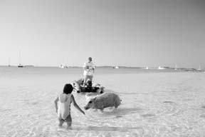 |
Kenna meets the official greeter at "Pig Beach" near Staniel Cay in the Exumas |
We also visited "pig beach" where two wild pigs live. When the female pig hears a dinghy coming she will actually swim out to greet it. She practically gets in the dinghy in her search for food. Also on pig beach is the newest attraction. During the "BIG" storm a Haitian refugee sailboat was pushed up onto pig beach. Their sailboat has become a playground for kids who like to swing in the rigging.
One day at Staniel, Tom and I went off snorkeling without the kids. We found loads of conchs, but Tom had to fend off a curious barracuda with his spear while he collected them. I’m not sure I can recommend his method of conch collecting. Then I speared my first fish, a triggerfish - which is a good panfish. Back on the boat Tom had his hands full trying to figure out how to get the conch meat out of the shell. It can be quite an ordeal until you get the knack of it but they were wonderful, as was the triggerfish.
Another day while we were snorkeling, Tom saw both a sea turtle and a nurse shark. Tom chases lots of big grouper around with his sling, but they are fast and very difficult to get. He also has been searching for lobsters spiny lobsters but without any luck. They are getting harder and harder to find down here by the average snorkeler. It is illegal to get them while you’re scuba diving or by trapping unless you’re a Bahamian with a special license. One day Tom went out with a friend he met - but no luck. But I thought it was funny that back in the states, this guy is a commercial lobsterman.
The main attraction at Staniel Cay is the "grotto." It is a cave that you can snorkel into a low tide or dive into at high tide. It is called Thunderball Cave because it is where the James Bond movie "Thunderball" was filmed. Also, Disney’s mermaid movie, "Splash" was filmed here. The cave is gorgeous with a huge variety of colorful fish. Inside, the cave opens way up and is quite large. We spent two afternoons snorkeling here and then went back again, this time with some of the girls’ friends. We would jump out of the dinghy and immediately be "attacked" by sergeant majors in search of a snack. The girls usually obliged by bringing a banana which the fish would happily nibble on.
Our next stop was at a town called Blackpoint. It isn’t much visited by cruisers so it felt good to get off the beaten path a bit. We caught a four foot barracuda coming into the harbor on one of our handlines but let it go. We walked around this sleepy little village. Flowers bloomed and filled the air with their sweet scent and native boats were beached under lazily curved palm trees. It was an idyllic setting and the people here were, as elsewhere in the Exumas, laid back and friendly.
The following day we sailed down to a place called Farmer’s Cay which also has a small town. Here we finally bought some fresh lobster. We got two tails, weighing about one and a half pounds together, for $10. We also found New Zealand canned butter in the grocery store. We haven’t had any ice in our "ice box" since Florida so canned butter was a real treat with the lobster.
Finally, it was time to head down to our southernmost destination, George Town. It was about a 35 mile trip and we averaged over six knots under sail. Exuma Sound was nearly calm, the sun was shining. It was the perfect sail. We had two handlines out but didn’t even have a nibble. We were hoping to catch a Mahi Mahi. Kate practiced taking sunshots with the sextant for math class.
George Town, capitol of the Exumas, is located on the biggest island in the Exumas; Great Exuma. George Town is also the place that lures the most cruising boats. When we arrived there were 375 cruising boats in the harbor. Fortunately, the harbor is huge; about five miles long and actually has many different anchorages. So there was plenty of room for "Out of Bounds." As we entered George Town we were besieged with calls from friends over the VHF. They all had the same basic message. "Glad you’re here. You’re going to stay for regatta aren’t you?"
Barbara Theisen lives aboard "Out of Bounds" with her two daughters, Kate and Kenna, and her husband, Tom.
All contents are copyright (c) 1998 by Northern Breezes, Inc. All information contained within is deemed reliable but carries no guarantees. Reproduction of any part or whole of this publication in any form by mechanical or electronic means, including information retrieval is prohibited except by consent of the publisher.