 Office of Coast Survey
The Nation's Nautical Chartmaker Office of Coast Survey
The Nation's Nautical Chartmaker
Would boaters use QR codes if they are on Print-on-Demand nautical charts?
NOAA's Print-on-Demand paper charts may provide a unique service in the coming months. Don't worry, you will still get all the accurate and precise chart information you rely on - but you may also get a little more real-time interactivity. Coast Survey is evaluating whether to add QR codes to POD nautical charts, so boaters can use their smartphones to get real-time information.
 Quick response codes (QR codes) are 2-dimensional bar codes, like the image on the left. When you scan a QR code with an iPhone, Android or other camera-enabled smartphone, you can link to digital content on the Internet. (You may need to download a free QR code reader application to your smartphone first). Quick response codes (QR codes) are 2-dimensional bar codes, like the image on the left. When you scan a QR code with an iPhone, Android or other camera-enabled smartphone, you can link to digital content on the Internet. (You may need to download a free QR code reader application to your smartphone first).
The nautical chart QR codes that we are testing would bring the smartphone user to a site that provides essential information specific to the location depicted on the chart. For instance, if you used the code on Chart 11416 Tampa Bay, you would get a link to the tides, air/water temperature, barometric pressure, wind, and other information specific to Tampa Bay. This webpage gives you some QR codes that you can try out. (If you prefer, you can go directly to a sample interactive page for Chart 11416.)
What do you think? Would mariners - especially recreational boaters who do not have an electronic charting system or a computer on board - find QR codes useful? Coast Survey wants your opinion. Particularly, we are assessing:
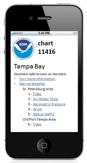
Coast Survey is testing QR codes on POD nautical charts. For instance, the QR code on chart 11416 would lead to important information on your smartphone.
You can contribute your comments on the evaluation topics listed above. Send an email to QRcodeCharts@noaa.gov or leave a voicemail at 888-990-6622.
Coast Survey is evaluating the QR codes as a free service that would be added to NOAA's Print-on-Demand charts, available commercially from OceanGrafix and East View Geospatial.
-------------------------------------------------------------------------------------------------------------------------------------------------------
Coast Pilot now updated weekly!
Get them free on the web, or as Print-on-Demand from agents.
Coast Survey now offers completed updated editions of the nine U.S. Coast Pilot volumes every week. The new (free) PDF versions, available on Coast Survey's website every Tuesday, will automatically incorporate the latest corrections. Print-on-Demand copies, produced from the same updated files, are available for sale by authorized printing partners. (NOAA will continue to print new editions annually for customers who prefer the traditional book.) See more information on the updated editions of the United States Coast Pilot.
TOP
|