
NOAA: Atlantic hurricane season stays quiet as predicted
Improved model, new surge forecast products and research projects debuted
The Atlantic hurricane season will officially end November 30, and will be remembered as a relatively quiet season as was predicted. Still, the season afforded NOAA scientists with opportunities to produce new forecast products, showcase successful modeling advancements, and conduct research to benefit future forecasts.
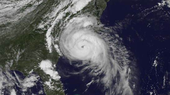
NOAA satellite image of Hurricane Arthur; July 3, 2014. (Credit: NOAA)
"Fortunately, much of the U.S. coastline was spared this year with only one landfalling hurricane along the East Coast. Nevertheless, we know that's not always going to be the case," said Louis Uccellini, Ph.D., director of NOAA's National Weather Service. "The 'off season' between now and the start of next year's hurricane season is the best time for communities to refine their response plans and for businesses and individuals to make sure they're prepared for any potential storm."
How the Atlantic Basin seasonal outlooks from NOAA's Climate Prediction Center verified:
| |
Actual |
August Outlook |
May Outlook |
| Named storms (top winds of 39 mph or higher) |
8 |
7-12 |
8-13 |
| Hurricanes (top winds of 74 mph or higher) |
6 |
3-6 |
3-6 |
| Major hurricanes (Category 3, 4, 5; winds of at least 111 mph) |
2 |
0-2 |
1-2 |
"A combination of atmospheric conditions acted to suppress the Atlantic hurricane season, including very strong vertical wind shear, combined with increased atmospheric stability, stronger sinking motion and drier air across the tropical Atlantic," said Gerry Bell, Ph.D., lead hurricane forecaster at NOAA's Climate Prediction Center. "Also, the West African monsoon was near- to below average, making it more difficult for African easterly waves to develop."
Meanwhile, the eastern North Pacific hurricane season met or exceeded expectations with 20 named storms - the busiest since 1992. Of those, 14 became hurricanes and eight were major hurricanes. NOAA's seasonal hurricane outlook called for 14 to 20 named storms, including seven to 11 hurricanes, of which three to six were expected to become major hurricanes. Two hurricanes (Odile and Simon) brought much-needed moisture to the parts of the southwestern U.S., with very heavy rain from Simon causing flooding in some areas.
"Conditions that favored an above-normal eastern Pacific hurricane season included weak vertical wind shear, exceptionally moist and unstable air, and a strong ridge of high pressure in the upper atmosphere that helped to keep storms in a conducive environment for extended periods," added Bell.
In the central North Pacific hurricane basin, there were five named storms (four hurricanes, including a major hurricane, and one tropical storm). NOAA's seasonal hurricane outlook called for four to seven tropical cyclones to affect the central Pacific this season. The most notable storm was major Hurricane Iselle, which hit the Big Island of Hawaii in early August as a tropical storm, and was the first tropical cyclone to make landfall in the main Hawaiian Islands since Hurricane Iniki in 1992. Hurricane Ana was also notable in that it was the longest-lived tropical cyclone (13 days) of the season and the longest-lived central Pacific storm of the satellite era.
New & improved products this year
As part of its efforts to provide better products and services, NOAA's National Weather Service introduced many new and experimental products that are already paying off.
The upgrade of the Hurricane Weather Research and Forecasting (HWRF) model in June with increased vertical resolution and improved physics produced excellent forecasts for Hurricane Arthur's landfall in the Outer Banks of North Carolina, and provided outstanding track forecasts in the Atlantic basin through the season. The model, developed by NOAA researchers, is also providing guidance on tropical cyclones in other basins globally, including the Western Pacific and North Indian Ocean basins, benefiting the Joint Typhoon Warning Center and several international operational forecast agencies. The Global Forecast System (GFS) model has also been a valuable tool over the last couple of hurricane seasons, providing excellent guidance in track forecasts out to 120 hours.
In 2014, NOAA's National Hurricane Center introduced an experimental five-day Graphical Tropical Weather Outlook to accompany its text product for both the Atlantic and eastern North Pacific basins. The new graphics indicate the likelihood of development and the potential formation areas of new tropical cyclones during the next five days. NHC also introduced an experimental Potential Storm Surge Flooding Map for those areas along the Gulf and Atlantic coasts of the United States at risk of storm surge from an approaching tropical cyclone. First used on July 1 as a strengthening Tropical Storm Arthur targeted the North Carolina coastline, the map highlights those geographical areas where inundation from storm surge could occur and the height above ground that the water could reach.
Beginning with the 2015 hurricane season, NHC plans to offer a real-time experimental storm surge watch/warning graphic for areas along the Gulf and Atlantic coasts of the United States where there is a danger of life-threatening storm surge inundation from an approaching tropical cyclone.
Fostering further improvements
While this year's hurricane season was fairly quiet, NOAA scientists used new tools that have the potential to improve hurricane track and intensity forecasts. Several of these tools resulted from research projects supported by the Disaster Relief Appropriations Act of 2013, which was passed by Congress in the wake of Hurricane Sandy.
Among the highlights were both manned and unmanned aircraft missions in Atlantic hurricanes to collect data and evaluate forecast models. NOAA and NASA's missions involving the Global Hawk, an unmanned aircraft that flies at higher altitudes and for longer periods of time than manned aircraft, allowed scientists to sample weather information off the west coast of Africa where hurricanes form, and also to investigate Hurricane Edouard's inner core with eight crossings over the hurricane's eye. NOAA launched a three-year project to assess the impact of data collected by the Global Hawk on forecast models and to design sampling strategies to improve model forecasts of hurricane track and intensity.
While the Global Hawk flew high above hurricanes, NOAA used the much smaller Coyote, an unmanned aircraft system released from NOAA's hurricane hunter manned aircraft, to collect wind, temperature and other weather data in hurricane force winds during Edouard. The Coyote flew into areas of the storm that would be too dangerous for manned aircraft, sampling weather in and around the eyewall at very low altitudes. In addition, NOAA's hurricane hunters gathered data in Hurricanes Arthur, Bertha and Cristobal, providing information to improve forecasts and to test, refine and improve forecast models. The missions were directed by research meteorologists from NOAA's Hurricane Research Division, a part of the Atlantic Oceanographic and Meteorological Laboratory in Miami, and the NOAA Aircraft Operations Center in Tampa.
In addition, increased research and operational computing capacity planned in 2015 will facilitate future model upgrades to the GFS and HWRF to include better model physics and higher resolution predictions. These upgraded models will provide improved guidance to forecasters leading to better hurricane track and intensity predictions.
The 2015 hurricane season begins June 1 for the Atlantic Basin and central North Pacific, and on May 15 for the eastern North Pacific. NOAA will issue seasonal outlooks for all three basins in May. Learn how to prepare at hurricanes.gov/prepare and FEMA's Ready.gov.
About NOAA
NOAA's mission is to understand and predict changes in the Earth's environment, from the depths of the ocean to the surface of the sun, and to conserve and manage our coastal and marine resources. www.nnvl.noaa.gov
TOP
|