Into the Ice
Return to the Northwest Passage
by Roger B. Swanson
Completing the 250 mile run to Upernavik, we anchored in the harbor the first night. In the morning we obtained permission to moor alongside a larger ship in the harbor closer inshore. It’s a good thing we did because the following morning a large grounded iceberg occupied our anchorage of the previous night. Upernavik is northern Greenland, well north of the areas normally visited by tourists. The brightly colored houses often need to be anchored to the rocky hillsides to keep them from sliding into the sea.
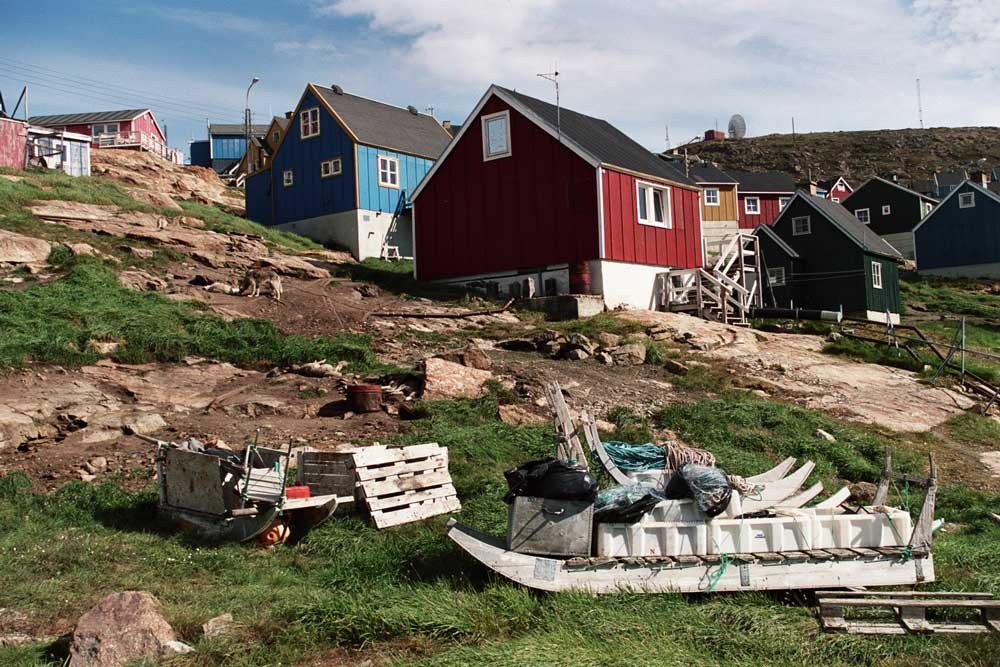 |
| Village of Upernavik—dog sleds in foreground. |
There are relatively few automobiles in Upernavik, mostly work related utility
vehicles, because there is little reason for a private individual to own a car.
The towns are small and there are no roads connecting the towns. The only
transportation out of the village is by boat in summer and dogsled or snowmobile
in winter. The towns have no central water or sewage system. Instead, homes have
a water tank filled periodically by truck and all sewage must be collected in
plastic bags and picked up by the local honey wagon.
Baffin Bay was still frozen so we had no choice but to wait at Upernavik before
we could continue and eventually cross to Canada. Cloud Nine had to move several
times to accommodate other boats moving around in the harbor. This was a
nuisance, but such is life in a Greenland seaport.
Since arriving in Greenland waters, we’ve had problems with our high frequency
radio communication. With the help of a capable local technician we rechecked
our equipment. He confirmed our previous conclusion that the problems were
related to high latitude sunspot activity that was especially bad this year. We
could get good weather and ice information from the harbormaster’s office, but
once we were underway, reports were intermittent.
After six days of waiting at Upernavik, ice reports showed improved conditions
and at 0030 on July 23, Cloud Nine headed north again. Our plan was to visit
Devil’s Thumb, the old whaler’s landmark located about 110 miles north of
Upernavik. All went well at first, but later in the day we encountered a heavy
iceberg concentration near Wilcox Head, a peninsula just south of Devil’s Thumb.
Carefully picking our way between the towering icebergs, we rounded Wilcox Head
and sighted the stark towering rock promontory known as Devil’s Thumb at 74-37N,
57-10W.
Early whalers used this route to reach the “North Water”, a productive whaling
area about 300 miles northwest of our present position that remained open much
of the year. Like ourselves, they followed the opening of the ice along the west
coast of Greenland to reach the open North Water as soon as possible to maximize
their whaling season. Because of navigation difficulties in the high latitudes,
they were often unsure of their location and sighting distinctive Devil’s Thumb
confirmed their position.
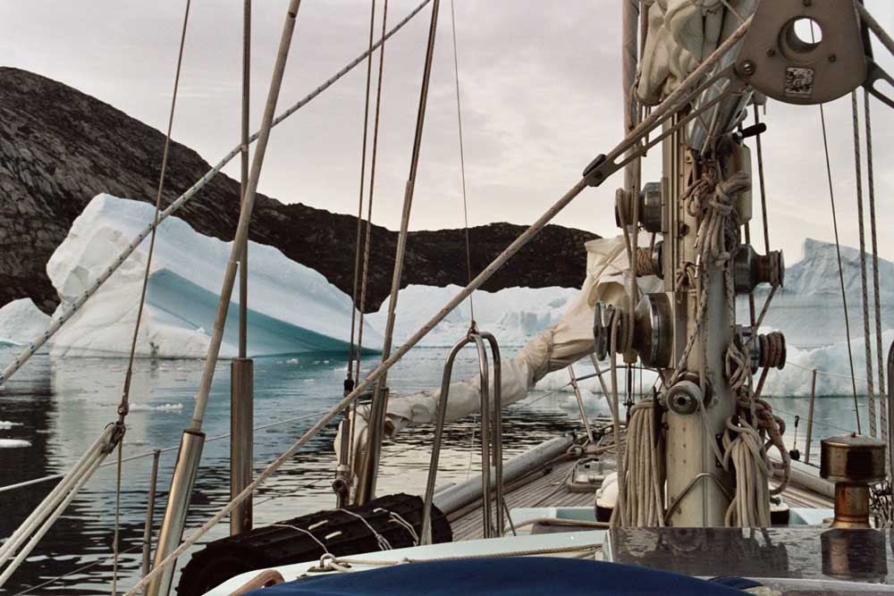 |
| Heavy Ice as we approached Devil’s Thumb. |
Our plan was to spend the night at the village of Kullorsuaq located near
Devil’s Thumb, but there was too much ice in the harbor for us to anchor. If an
iceberg were to drift over our chain we would be unable to retrieve our anchor
and probably lose both anchor and chain. A Danish freighter, Green Igloo, gave
us permission to temporarily moor alongside while she was moving freight ashore
via a barge. I visited the captain on the bridge and he gave us current weather
and ice information as well as 25 gallons of diesel fuel to top up our tanks for
which he refused any payment. Three of our crew were able to slip ashore for a
short time to visit the village which they found more primitive than others we
had seen. This is the northern frontier.
Green Igloo planned to leave us soon as she completed her freight transfer so it
was necessary for us to move on. Since Baffin Bay was still icebound, the
freighter captain recommended that we return to Kraulshavn located about 30
miles south. It has a reasonably good harbor and might be a good place for us to
wait for ice conditions to improve. This seemed like a good suggestion. We found
no shortage of ice in the Kraulshavn harbor either, 74-05.7N, 57-03.9W, but
located a satisfactory spot and anchored at 0740 on July 24 after which we
turned in to get some much needed sleep.
Kraulshavn was another frontier village, small and untidy, with no vehicles and
not even a water truck. To wash, the inhabitants needed to reserve time at a
central facility for laundry and showers. We did the same. Conditions were not
ideal, but we could remain here as long as necessary to wait for the ice to open
up. As usual we had to reanchor occasionally to avoid ice moving around inside
the harbor. Two days of good radio propagation informed us there was now an open
lead northwest across Baffin Bay, but the passages in northern Canada were still
blocked.
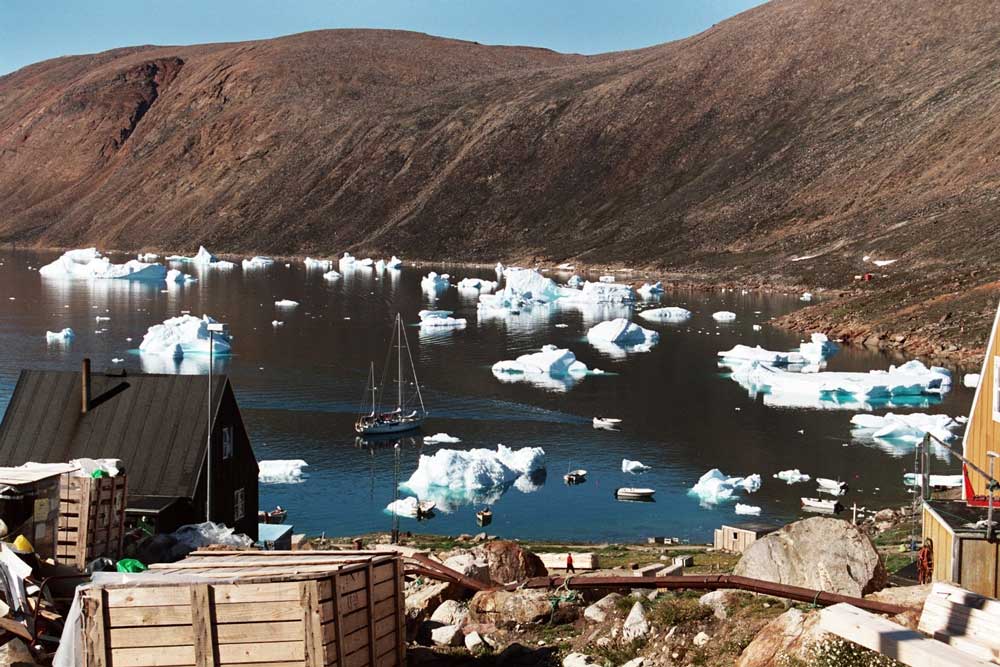 |
| Cloud Nine in the harbor at Kraulshavn waiting for ice to open across Baffin Bay. |
A few days later we decided to go. There was a lot of ice for the first five
miles, but then it thinned out and our progress improved. Our course was
northwest and when the fog cleared we saw Devil’s Thumb again on the horizon 35
miles away! The temperature was 39 degrees Fahrenheit and the weather
exceptionally clear as we continued across Baffin Bay. Another important
landmark was Cape York on the southwest tip of the western bulge of Greenland,
clearly visible nearly 40 miles off our starboard beam. On July 29 we reached
the northernmost point of our trip at 75-26.7N, 69-19.2W. At this time we
exchanged our Greenland courtesy flag for the Canadian and turned southwest
toward Lancaster Sound.
Lancaster Sound contained only scattered ice allowing us to continue another 200
miles along the south coast of Devon Island. Once in Canadian Arctic waters, we
were so close to the magnetic north pole that our magnetic compass was
completely useless. If out of visual contact with land, we were dependent on our
GPS (global positioning system) equipment to determine, not only our position,
but also our course when we were underway. Since we were making good progress,
we decided to bypass Erebus Bay at the southwest corner of Devon Island and try
to reach Resolute on Cornwallis Island where we could get detailed weather and
ice information. While passing Erebus Bay, Doug spotted a mast in the harbor
causing us to immediately alter course and head in. It was Skip Novak on Pelagic
Australis who had anchored here only a few hours earlier after returning from
Resolute. What a coincidence! Although we knew he was making a Northwest Passage
attempt, we had not been able to establish radio contact.
To continue the Northwest Passage quest from here it was necessary to first head
south about 400 miles to Gjoa Haven on King William Island before turning west
again toward Point Barrow. Skip had the latest satellite communication equipment
on board and was able to inform us that the passages south from here, Peel
Sound, Franklin Strait, Larson Sound, and James Ross Strait were still filled
with ice. Since there was no reason to push on from here at this time, there was
nothing to do but wait.
Erebus Bay is where the ill fated Franklin expedition consisting of two ships,
Erebus and Terror, spent their first winter in 1846-47. Three men died that
winter and were buried ashore, but the expedition continued the following year.
The ships became trapped and crushed in the ice pack and eventually all 129 men
perished. Following their loss, Lady Franklin financed several expeditions to
the Arctic to attempt to learn their fate. Her influence also resulted in the
British government sending additional search expeditions. These efforts greatly
increased knowledge of the Arctic, but none of them succeeded in making it
through the Northwest Passage. After 400 years of attempts, it wasn’t until 1907
that the passage was finally completed by the Norwegian explorer, Roald
Amundsen, after spending two winters in the Canadian Arctic.
We went ashore with the dinghy at Erebus Bay to visit the three Franklin graves.
Near the gravesite is a brass cylinder where visitors can leave notes or other
memorabilia to commemorate their stop here. At the time of my ’94 visit, I left
a short note and a photograph of Cloud Nine in the cylinder. On this trip I was
pleased to find it was still there and in good condition. When going ashore we
always carried a loaded shotgun to protect ourselves from polar bears. Polar
bears are one of the few animals in nature that will deliberately stalk and
attack human beings. We saw several during our time in the Arctic, but
fortunately had no life threatening encounters with them.
The next day we left for Resolute and immediately ran into ice. Pack ice
coverage is usually specified in tenths with 0/10 being open water and 10/10
being solid ice coverage. The most ice we can attempt to navigate with Cloud
Nine is 3 to 4/10. When underway in 3/10 or more pack ice, we normally use a
boatswain’s chair to put one crew member up the mast on a spreader. From this
point he is in a good position to survey the ice ahead looking for leads through
the pack and direct the helmsman to follow them.
The next several hours were spent working our way through about 30 miles of 2 to
4/10 ice before reaching the southeast corner of Cornwallis Island after which
we were able to follow the south coast in relatively open water to Resolute. We
anchored late in the evening of August 2 on the east side of the bay following a
10 hour passage from Erebus. This was quite a contrast from our experience 11
years ago when it took two weeks with many serious ice problems to make this
same passage.
The next morning we were happy to be in a sheltered harbor because the wind came
up from the southeast and blew up to 40 knots for the next three days making it
impossible for us to get ashore. Ice blew into the harbor with this wind, but
fortunately remained on the west side and was not a problem for us. Finally on
August 6 the wind went down and we reanchored near the hotel, South Camp Inn.
This is the jumping off place for many polar expeditions and its owner, Aziz
Kheraj was very helpful.
We topped off 130 gallons of diesel fuel and 200 gallons of water, all carried
in jerry cans from shore in our dinghy. The winds were back up to 25 knots
making for cold wet work. Showers and laundry facilities were available at the
hotel. Both of these services were badly needed and much appreciated by our
crew. Gaynelle picked up a few groceries, but with eggs at $3.00 a dozen, we
kept our purchases to a minimum. Aziz was able to rent us an iridium telephone
that improved our communication reliability.
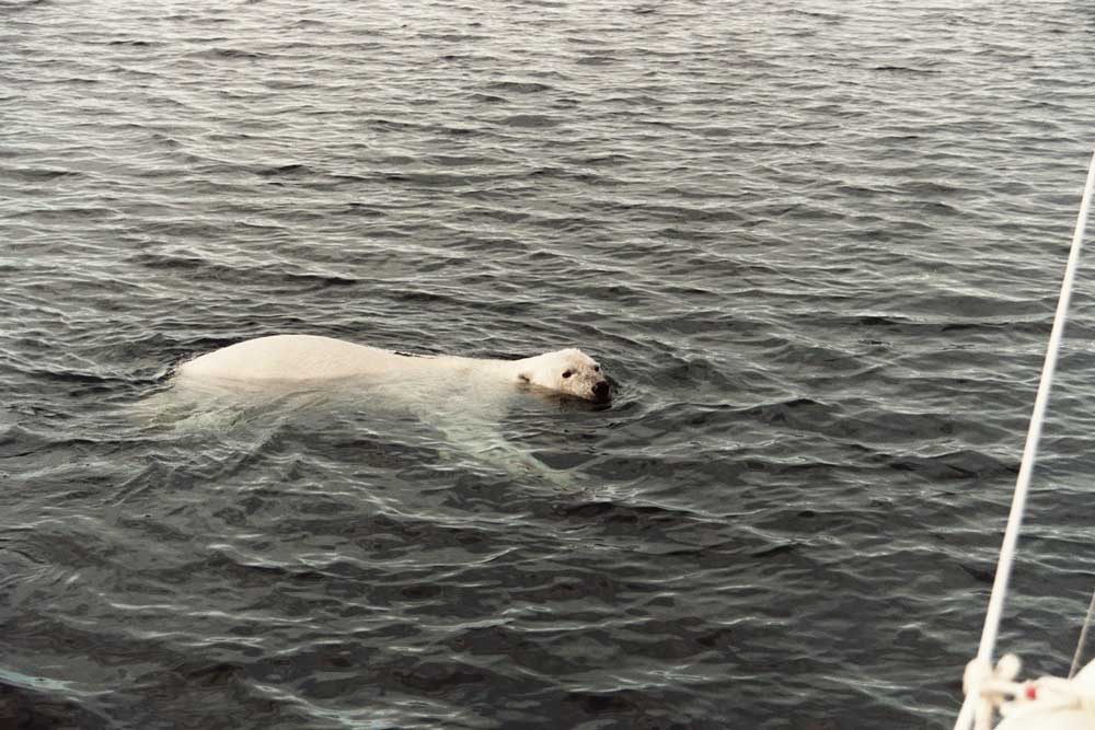 |
| Polar Bear looking for a way to board Cloud Nine. |
At this point Cloud Nine was short one crew member because one of our
group left at Resolute. At the hotel we met Judd Reed who had just finished a
four week tour of duty with the Mars Society and was waiting for a flight home.
The Mars Society is a scientific group that has chosen this area to conduct its
research because it believes the terrain on nearby Devon Island closely
resembles that of Mars. Judd realized we had a vacancy and expressed an interest
in joining us. Decisions came rapidly and within two hours he had cancelled his
flight home and moved aboard Cloud Nine.
The ice passages south of Resolute had not opened, but we needed to find another
place to wait. We had been trapped here for several days by ice both inside and
outside the harbor making getting out of Resolute our first priority. On August
8, after examining the ice reports, we managed to work through the ice outside
the harbor and head east along the south shore of Cornwallis Island. During the
next four hours we twisted our way through 10 miles of 2 to 4/10 ice. At one
point we were nearly beset but succeeded in freeing ourselves and continued on.
A short time later we came to a solid wall of ice floes reaching from the
offshore pack all the way to the Cornwallis shoreline. There was no choice but
to turn back and return to Resolute. That night we had to relocate when a large
ice floe moved over our anchor. Cloud Nine was able to push the ice far enough
upwind to allow us to retrieve our anchor and move to another area in the
harbor.
On the morning of Aug 10 Judd and I went ashore, borrowed an ATV from Aziz, and
took a three hour ride over the hills overlooking the harbor and the waters
outside. Judd’s familiarity with this rough and rocky terrain was invaluable. It
was necessary to avoid slowing down in wet areas to keep from getting stuck in
the permafrost. At one point we had to both jump off and push while keeping the
ATV driving to avoid sinking into the bog. We got a pretty good view of the
waters offshore and the situation looked encouraging.
That afternoon we were underway and once again made our way through the ice
outside the harbor. Based on our ATV survey, we did not turn east along the
south shore of Cornwallis Island as before, but headed southwest crossing over
to Griffith Island where there appeared to be less ice. We worked through about
8 miles of 1 to 3 tenths ice to reach the thinner ice along the island shoreline
where we turned southeast. Motorsailing past Griffith Island brought back vivid
memories for me because it was here in 1994, that Cloud Nine narrowly escaped
being driven ashore by a massive ice floe after being imprisoned by pack for
four days. We continued to weave our way southeast through the ice another five
miles past the southeast tip of Griffith Island where the concentration thinned
to one tenth or less and we made good time.
This has been an excerpt from Roger Swanson’s book Into the Ice.
In the next installment Swanson and his crew sail through the ice and meet Jotun
Arctic, their partner for the rest of the Northwest Passage.
Roger Swanson is from Dunnell, Minnesota. He has cruised Antarctica
twice, almost the Northwest Passage and circumnavigated four times.He has
received numerous international awards for cruising and seamanship.